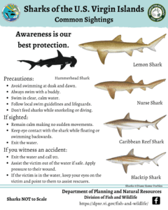
Other sharks are also commonly found in our waters too. Sharks targeting fish and turtles include Tiger sharks and Bull sharks in many of our common fishing grounds.
The U.S. Virgin Islands Department of Planning and Natural Resources (DPNR) Division of Fish and Wildlife (DFW) has an extensive data collection program on the commercial fisheries of the USVI. However, the recreational fishery is just as important to the local economy, culture, and recreation. In order to preserve and maintain our fishery resources, DFW has begun collecting data on our important recreational fisheries.
In 2017, a recreational fishing report form was developed and disseminated to the recreational fishing communities to begin collecting information on fishing activity and landings. In addition to our continued data collection at over 10 annual sportfishing tournaments in the Territory, this has enhanced what is known about the local recreational fishery.
Information on fishing activity and landings is essential to successful management of our recreational fisheries. Whether you:
We need your help! We have created an online form to make it easy for recreational anglers to report their catch. We ask that all fishers submit this voluntary report each time you go fishing as part of the recreational fishing licensing program. The survey collects information about your fishing trip, your vessel, and your catch. Your data will remain confidential and will contribute to better management of our fisheries, supporting their sustainability for generations to come.
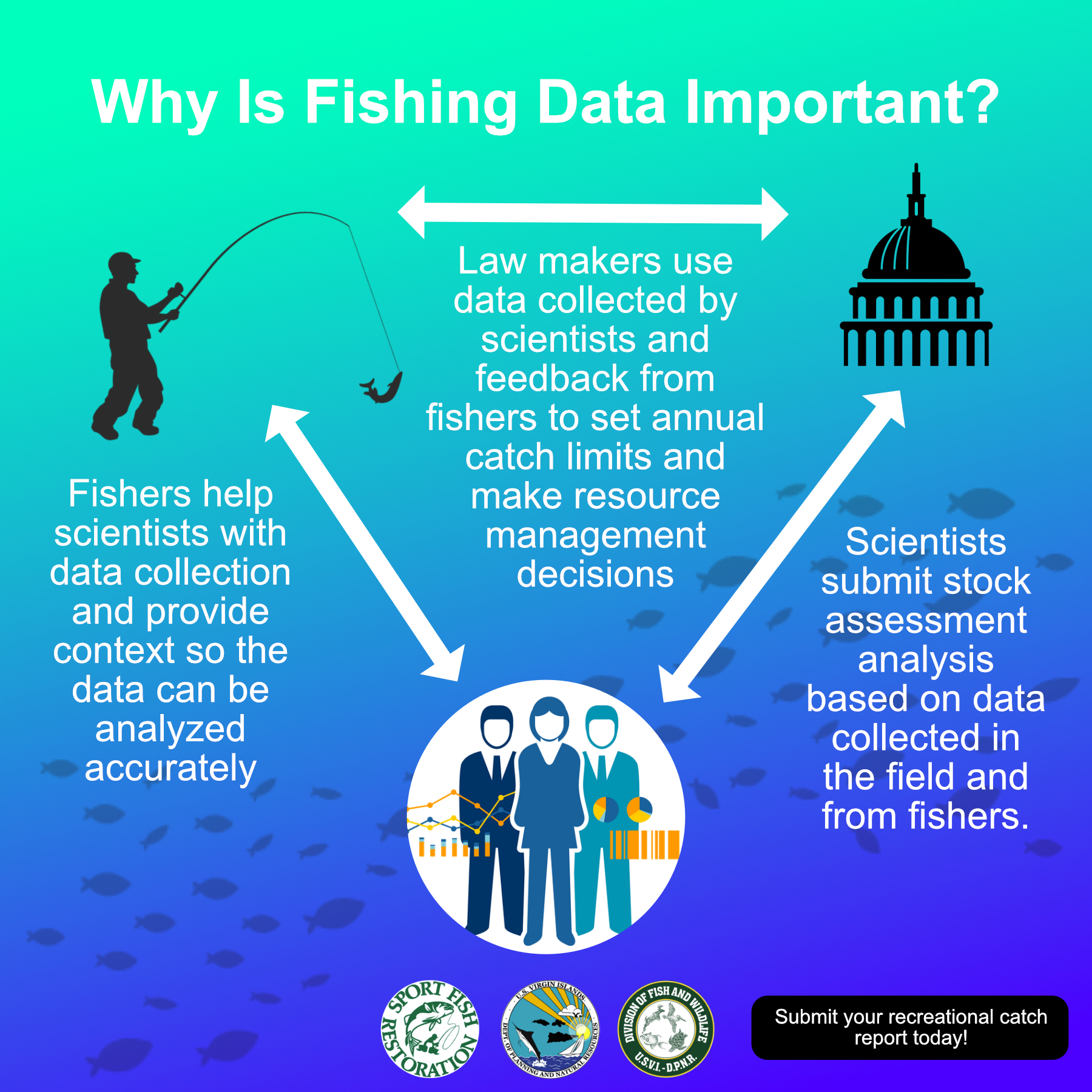
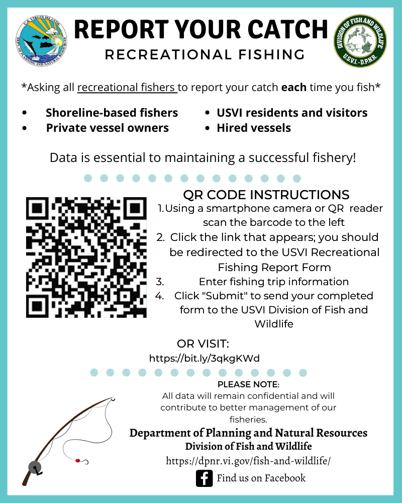
The current VI Recreational Fishery Project allows DFW to expand our data collection and analysis efforts even further, involving online reporting and paper logbooks that are available to frequent fishers and fishing charter operations. The report form can be accessed at the web link here or by using the Quick Response (QR) Code below.
QR Code Instructions:
Dolphinfish Tagging Program
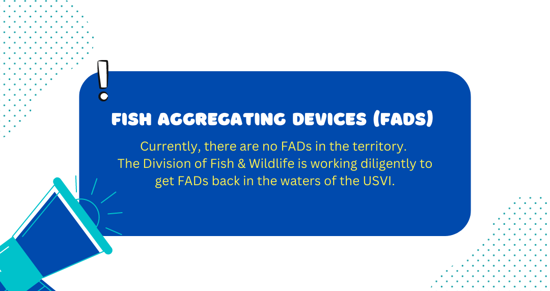
As part of the USVI Fish Aggregating Devices Program, the Division of Fish and Wildlife partners with the Dolphinfish Research Program (DRP) (http://dolphintagging.com/) and the Beyond Our Shores Foundation (https://beyondourshores.org/) to expand their dolphinfish tagging program to the U.S. Virgin Islands. Polyethylene dart tags are distributed to recreational, charter, and commercial fishers who volunteer to participate in the program. Anglers tag dolphinfish they catch near the USVI Fish Aggregating Devices (FADs), record the length of the fish, and release the fish unharmed back into the water. Anglers then submit the tagging location and related information back to the Dolphinfish Research Program and Beyond Our Shores. Anglers who capture a fish that has already been tagged may submit a Recapture Report at https://beyondourshores.org/report-recapture/. This important program helps to collect information on dolphinfish movements, range, and recreational fishing activity around the Caribbean and wider Atlantic region.
If you are an angler based in the USVI and would like to participate in the dolphinfish tagging program, contact us to obtain a free tagging kit.
Recreational Fisheries
The U.S. Virgin Islands has an extremely active recreational fishery known for its access to coastal as well as offshore fishing. Targeted species range from large pelagics and billfish (wahoo, dolphinfish, tunas, blue marlin, white marlin) to coastal pelagics (king mackerel, cero mackerel, barracuda, jacks), and reef fish (grouper, snapper, triggerfish, and more). The USVI recreational fishery consists of shoreline fishers, private use vessels, and charter operations.
“Recreational fishing” is defined as “fishing or fishing activities which result in the harvest of fish, none of which (or parts thereof) is sold, traded, or bartered” (50 CFR 622.2). Sale, barter, or trade of catch by recreational fishers is prohibited. The following gear types are considered commercial gear and may not be used by recreational fishers: pots, traps, and seines.
Fishing Tournaments
There are several sportfishing tournaments hosted in the U.S. Virgin Islands each year. The tournaments are hosted by local fishing clubs and organizations, such as the Virgin Islands Game Fish Club, Golden Hook Fishing Club, Virgin Islands for Veterans (VI4Vets), and the Northside Sportfishing Club.
The Division of Fish and Wildlife serves as weighmasters at many of these tournaments. For each fish landed, we identify the species, weigh the fish, and measure the fork length of the fish. We also collect fishing effort data, including fishing area, number of anglers, length of time spent fishing, gear type used, and more. Species targeted in the tournaments include coastal pelagics (e.g., Kingfish Shootout, Bastille Day Kingfish Tournament), offshore pelagics (e.g., Wahoo Windup, Dolphin Derby), and shallow-water gamefish and reef fish (e.g., St. Thomas Spearfishing tournament).
The purpose of the Fisheries Cooperative Statistics Program (CSP) is to maintain a Territorial and Federal partnership to collect fisheries-dependent statistics in support of fisheries management following the Magnuson-Stevens Fishery Conservation Management Act. Program objectives include:
Commercial Fishery-Dependent Sampling
As part of the CSP program, DFW conducts fisheries-dependent sampling by measuring commercial catches and interviewing the fishers (also referred to as “port sampling” or “creel surveys”). During these surveys, DFW staff meet fishers at the various fishing ports around the islands and collect information about the fishers’ catch. We identify, measure, and weigh the individual fish and lobster in the catch. We also interview the fishers to collect effort and gear information, including length of time spent fishing (soak time), fishing area, gear type used, landing site, and crew size. These surveys enhance our understanding of the commercial fishery by collecting more detailed data than what is reported by fishers on their commercial catch report forms (CCRs).
Sampling is conducted weekly on a random basis from Monday through Friday, from 8 am to 5 pm. Sampling is also conducted after-hours on a scheduled basis for fishers who return to their port in the early morning, late at night, or on weekends. This facilitates data collection that is representative of the entire commercial fishery. Data are entered into an online database which is managed by NOAA Fisheries. From this data, we can obtain valuable metrics including annual landings; landings by district, port, and month; and trends in gear usage or fishing effort.
Fisheries-Independent Sampling
Southeast Area Monitoring and Assessment Program – Caribbean
The Southeast Area Monitoring and Assessment Program – Caribbean (SEAMAP-C) provides efficient and effective data collection of fishery-independent sampling. Goals of the study include enhancing understanding of 1) finfish population structure composition and 2) Queen Conch and Caribbean Spiny Lobster recruitment.
The program allows coordination of five-year studies in coordination with Puerto Rico’s Department of Environment & Natural Resources to collect information on finfish, Queen Conch, and Caribbean Spiny Lobster populations. Sampling methods utilize both active and passive techniques, including a camera video array, longline, and handline fishing. The sampling occurs at randomly stratified habitats and depths within territorial waters as well as within the Exclusive Economic Zone (EEZ) around the U.S. Virgin Islands. The data collected in this program informs management decisions made by local and federal resource managers at the NOAA Southeast Science Fisheries Center’s Caribbean Branch.
Back at DFW’s lab, fish are processed to measure fork/total length, total weight, gutted weight, sex, gonad stage, and gonad weight. Staff also extract otoliths from the fish. Otoliths are bony structures made of calcium carbonate located in the inner ear which assist fish in hearing, balance, and orientation. A new layer of bone is added to the otolith each year. Similar to growth rings of a tree, counting the bands of the otoliths provides an estimate of the fish’s age.
Interjurisdictional Fisheries Project
The Interjurisdictional Fishery Project supports projects ” (1) to promote and encourage state activities in support of the management of Interjurisdictional resources, and (2) to promote the management of interjurisdictional fisheries resources throughout their range” funded by NOAA Fisheries. At this time, the IJ project supports SEAMAP-C through obtaining environmental data at finfish, Queen Conch, and Spiny Lobster sampling sites.
Boating Access
The Division of Fish and Wildlife conducts improvements and repairs of public boating access facilities in the Territory and is a voting member of the States Association of Boating Access (SOBA). Ongoing work includes improvements to three boat ramp and dock facilities in St. Croix, one boat ramp facility in St. Thomas, and maintenance of transient moorings in St. Thomas. These projects also have an outreach component to engage the community and provide education on the locations of available facilities, safe usage of the facilities, and to solicit feedback and input during every step of the project.
Boating Access Facility Improvements in St. Croix and St. Thomas
The goal of the U.S. Virgin Islands Boating Access Program is to plan, build, and improve boating access facilities throughout St. Croix and St. Thomas. In St. Croix, two boat ramps and one dock are free to use and open to the public. These facilities are located at Frederiksted, Altona Lagoon, and Gallows Bay. On St. Thomas, there is a public boat access site located at Hull Bay, on the north side of the island.
This program is funded by the U.S. Fish and Wildlife Service Sport Fish Restoration Fund.
Christmas Cove Moorings
Transient mooring buoys offer numerous benefits to the recreational boating community and the marine environment. Anchoring of vessels causes damage to sensitive seagrass beds and coral, which function as essential fish habitat. Mooring fields eliminate boaters’ need to anchor while providing a safe, convenient alternative for them to secure their vessels. Moorings can mitigate damage to seagrass and other benthic habitats and promote their recovery from any sustained scarring or other damage.
Christmas Cove, St. Thomas, U.S. Virgin Islands, is located within the St. James Marine Reserve and Wildlife Sanctuary. Christmas Cove contains critical seagrass habitat and federally protected corals such as Acropora and Orbicella species. The area is subject to heavy usage by both local and visiting recreational boaters, snorkelers, SCUBA divers, and swimmers. To help conserve these sensitive habitats, the U.S. Fish and Wildlife Service’s Boating Infrastructure Grant (BIG) supported the installation of a mooring field in the area in 2010 – 2011. Twenty-two (22) transient moorings and three (3) informative signs listing rules and regulations of the area and eligible uses of the moorings were installed in Christmas Cove under these awards.
The Division of Fish and Wildlife conducted major repairs to the mooring field in 2017 and continues to maintain the moorings on an annual basis. This ensures that the moorings continue to safely serve the recreational boating community of the USVI and protect the ecological communities in the bay. Additionally, a three-year environmental monitoring program was implemented to monitor seagrass, coral, and fish communities in Christmas Cove. The monitoring program documents improvements to the surrounding habitat as a result of the mooring repairs and also documents the presence of sensitive or endangered species.
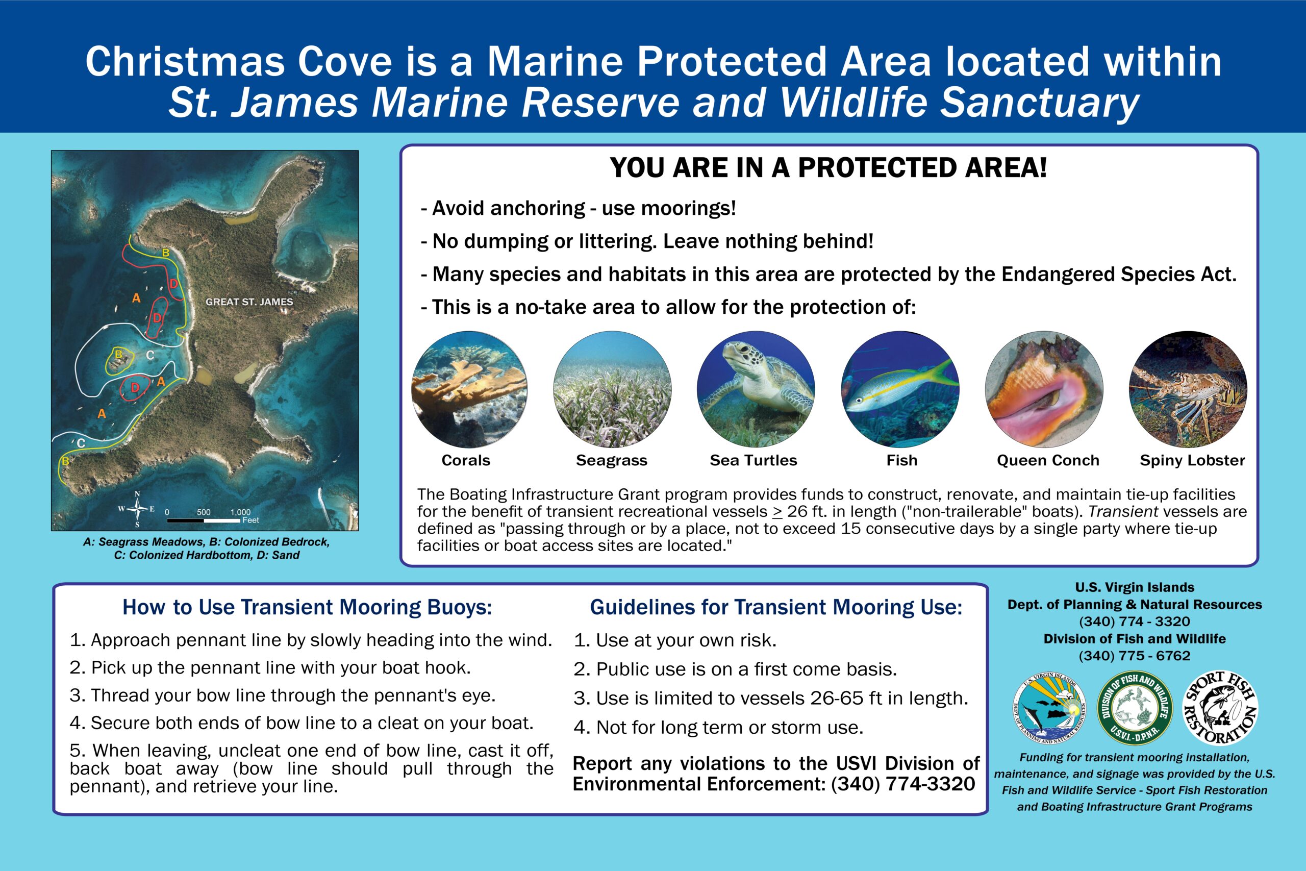
This program is funded by the U.S. Fish and Wildlife Service Sport Fish Restoration Fund.
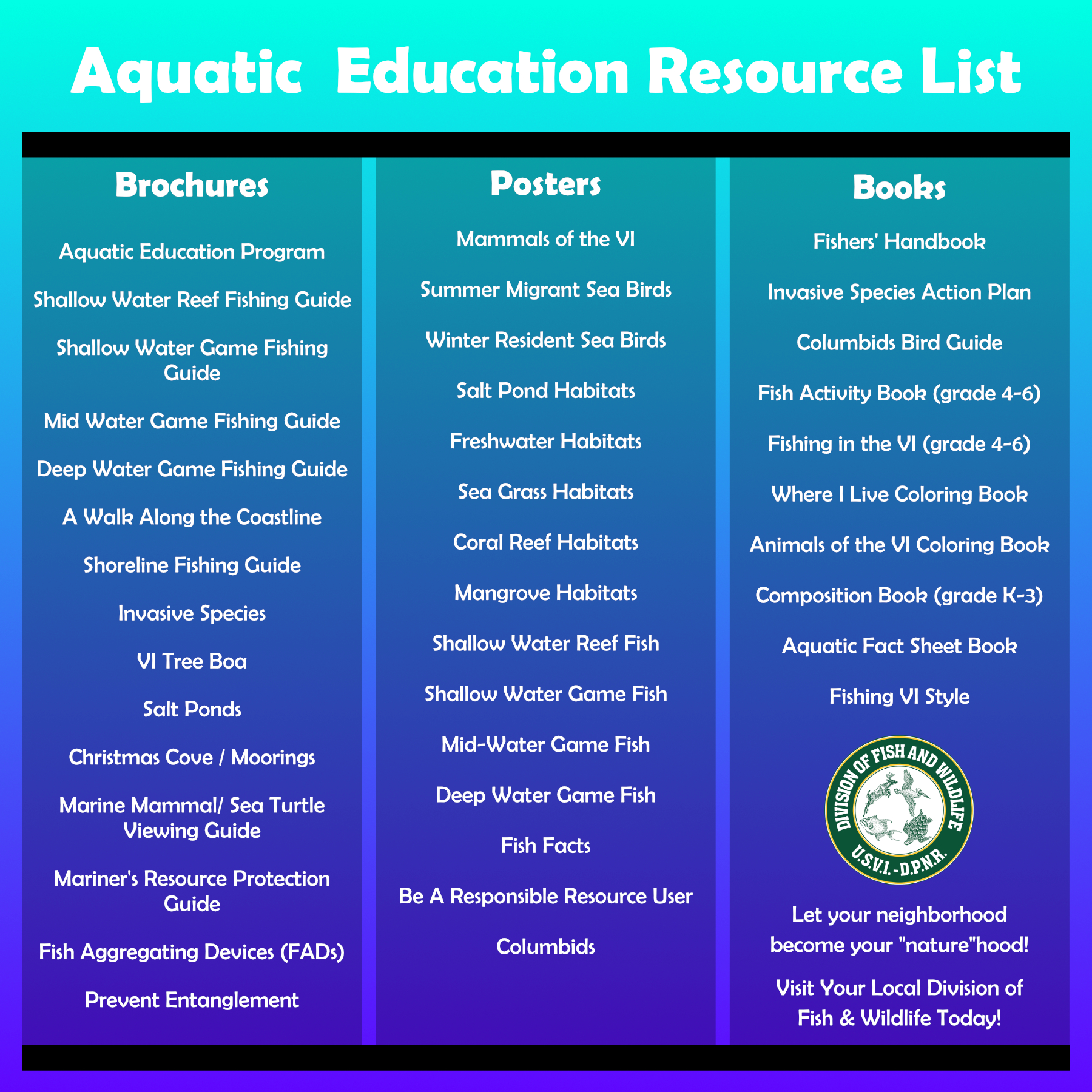
Outreach Materials & Resources
DFW offers a variety of educational resources for fishers and resource users in the U.S. Virgin Islands, including brochures, posters, and handheld tools.
Stop in to one of the Division of Fish and Wildlife offices in Red Hook, St. Thomas, or Frederiksted, St. Croix, to pick up copies of the brochures or other available resource materials!
Recreational fishing ad
Familiarize yourself with the Commercial Catch Report
STX Commercial Catch Report
STT & STJ Commercial Catch Reports
Print out your own fish ID ruler!
DFW fish ID ruler (front)
DFW fish ruler (back)
Fish the shorelines and shallow waters!
Shallow Water Game Fish Techniques
STX shoreline fishing guidelines &
STX shoreline fishing locations
STT shoreline fishing guidelines &
STT shoreline fishing locations
Virgin Islands Rules and Regulations Concerning: Commercial Fishing
Below are links to our partner agencies and programs:
Caribbean Fishery Management Council: https://www.caribbeanfmc.com/
NOAA National Marine Fisheries Service Permit Shop: https://hmspermits.noaa.gov
NOAA Southeast Regional Office Permit Shop: https://sero.nmfs.noaa.gov/permits
Virgin Islands Code: http://www.lexisnexis.com/hottopics/vicode/
U.S. Code of Federal Regulations: https://gov.ecfr.io/cgi-bin/ECFR
Virgin Islands Game Fishing Club (St. Thomas): https://www.vigfc.com/
Golden Hook Fishing Club (St. Croix): https://fishstx.wixsite.com/fishstx
Beyond Our Shores Foundation: https://beyondourshores.org/
Dolphinfish Research Program: http://www.dolphintagging.com/
Southeast Area Monitoring and Assessment Program-Caribbean (SEAMAP-C): https://sero.nmfs.noaa.gov/operations_management_information_services/state_federal_liaison_branch/seamap/index.html